Aberdeen (/ˌæbərˈdiːn/ (listen); Scots: Aiberdeen, listen (help·info); Scottish Gaelic: Obar Dheathain [opəɾ ˈɛ.ɛɲ]; Latin: Aberdonia) is a city in northeast Scotland. It is Scotland’s third most populous city, one of Scotland’s 32 local government council areas and the United Kingdom’s 39th most populous built-up area, with an official population estimate of 196,670 for the city of Aberdeen and 227,560 for the local council area.
During the mid-18th to mid-20th centuries, Aberdeen’s buildings incorporated locally quarried grey granite, which can sparkle like silver because of its high mica content. Since the discovery of North Sea oil in the 1970s, Aberdeen has been known as the off-shore oil capital of Europe. The area around Aberdeen has been settled for at least 8,000 years, when prehistoric villages lay around the mouths of the rivers Dee and Don. The city has a long, sandy coastline and a marine climate, the latter resulting in chilly summers and mild winters.
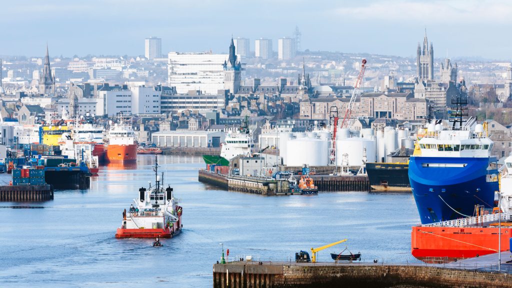
Aberdeen received Royal Burgh status from David I of Scotland (1124–1153), transforming the city economically. The city has two universities, the University of Aberdeen, founded in 1495, and Robert Gordon University, which was awarded university status in 1992, making Aberdeen the educational centre of north-east Scotland. The traditional industries of fishing, paper-making, shipbuilding, and textiles have been overtaken by the oil industry and Aberdeen’s seaport. Aberdeen Heliport is one of the busiest commercial heliports in the world and the seaport is the largest in the north-east of Scotland.
Aberdeen used to host the Aberdeen International Youth Festival, a major international event which attracted up to 1000 of the most talented young performing arts companies but the council ended funding in 2017 and the festival was wound up in 2018. In 2015, Mercer named Aberdeen the 57th most liveable city in the world, as well as the fourth most liveable city in Britain. In 2012, HSBC named Aberdeen as a leading business hub and one of eight ‘super cities’ spearheading the UK’s economy, marking it as the only city in Scotland to receive this accolade. In 2018, Aberdeen was found to be the best city in the UK to start a business in a study released by card payment firm Paymentsense.
The Town House, Old Aberdeen. Once a separate burgh, Old Aberdeen was incorporated into the city in 1891
The Aberdeen area has seen human settlement for at least 8,000 years. The city began as two separate burghs: Old Aberdeen at the mouth of the river Don; and New Aberdeen, a fishing and trading settlement, where the Denburn waterway entered the river Dee estuary.[14] The earliest charter was granted by William the Lion in 1179 and confirmed the corporate rights granted by David I.
In 1319, the Great Charter of Robert the Bruce transformed Aberdeen into a property-owning and financially independent community. Granted with it was the nearby Forest of Stockett, whose income formed the basis for the city’s Common Good Fund which still benefits Aberdonians.
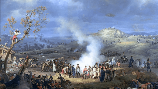
During the Wars of Scottish Independence, Aberdeen was under English rule, so Robert the Bruce laid siege to Aberdeen Castle before destroying it in 1308, followed executing the English garrison. The city was burned by Edward III of England in 1336, but was rebuilt and extended. The city was strongly fortified to prevent attacks by neighbouring lords, but the gates were removed by 1770.
The Powis gate, Old Aberdeen, built in 1834
During the Wars of the Three Kingdoms of 1644 to 1647, the city was plundered by both sides. In 1644, it was taken and ransacked by Royalist troops after the Battle of Aberdeen and two years later it was stormed by a Royalist force under the command of the Marquis of Huntly. In 1647 an outbreak of bubonic plague killed a quarter of the population. In the 18th century, a new Town Hall was built and the first social services appeared with the Infirmary at Woolmanhill in 1742 and the Lunatic Asylum in 1779. The council began major road improvements at the end of the 18th century with the main thoroughfares of George Street, King Street and Union Street all completed at the beginning of the 19th century.
Historical photos of Aberdeen c. 1900
The expensive infrastructure works led to the city becoming bankrupt in 1817 during the Post-Napoleonic depression, an economic downturn immediately after the Napoleonic Wars; but the city’s prosperity later recovered. The increasing economic importance of Aberdeen and the development of the shipbuilding and fishing industries led to the construction of the present harbour including Victoria Dock and the South Breakwater, and the extension of the North Pier. Gas street lighting arrived in 1824 and an enhanced water supply appeared in 1830 when water was pumped from the Dee to a reservoir in Union Place. An underground sewer system replaced open sewers in 1865. The city was incorporated in 1891. Although Old Aberdeen has a separate history and still holds its ancient charter, it is no longer officially independent. It is an integral part of the city, as is Woodside and the Royal Burgh of Torry to the south of the River Dee.
Over the course of the Second World War Aberdeen was attacked 32 times by the German Luftwaffe. One of the most devastating attacks was on Wednesday 21 April 1943 when 29 Luftwaffe Dornier 217s flying from Stavanger, Norway attacked the city between the hours of 22:17 and 23:04. A total of 98 civilians and 27 servicemen were killed, along with 9,668 houses damaged, after a mixture of 127 Incendiary, High Explosive and Cluster bombs were dropped on the city in one night. It was also the last German raid on a Scottish city during the war.
Toponymy
Main article: Etymology of Aberdeen
Aberdeen was in Pictish territory and became Gaelic-speaking at some time in the medieval period. Old Aberdeen is the approximate location of Aberdon, the first settlement of Aberdeen; this literally means “the mouth of the Don”. The Celtic word aber means “river mouth”, as in modern Welsh (Aberystwyth, Aberdare, Aberbeeg etc.). The Scottish Gaelic name is Obar Dheathain (variation: Obairreadhain; *obar presumably being a loan from the earlier Pictish; the Gaelic term is inbhir), and in Latin, the Romans referred to the river as Devana. Mediaeval (or Ecclesiastical) Latin has it as Aberdonia.
Governance
Aberdeen is locally governed by Aberdeen City Council, which comprises forty-five councillors who represent the city’s wards and is headed by the Lord Provost. The current Lord Provost is Barney Crockett. From May 2003 until May 2007 the council was run by a Liberal Democrat and Conservative Party coalition. Following the May 2007 local elections, the Liberal Democrats formed a new coalition with the Scottish National Party. After a later SNP by-election gain from the Conservatives, this coalition held 28 of the 43 seats. Following the election of 4 May 2017, the council was controlled by a coalition of Scottish Labour, Scottish Conservatives and independent councillors; the Labour councillors were subsequently suspended by Scottish Labour Party leader, Kezia Dugdale.
Aberdeen is represented in the Parliament of the United Kingdom by three constituencies: Aberdeen North and Aberdeen South which are wholly within the Aberdeen City council area, and Gordon, which includes a large area of the Aberdeenshire Council area.
In the Scottish Parliament, the city is represented by three constituencies with different boundaries: Aberdeen Central and Aberdeen Donside are wholly within the Aberdeen City council area. Aberdeen South and North Kincardine includes the North Kincardine ward of Aberdeenshire Council. A further seven MSPs are elected as part of the North East Scotland electoral region. In the European Parliament the city was represented by six MEPs as part of the all-inclusive Scotland constituency.
The arms and banner of the city show three silver towers on red. This motif dates from at least the time of Robert the Bruce and represents the buildings that stood on the three hills of medieval Aberdeen: Aberdeen Castle on Castle Hill (today’s Castlegate); the city gate on Port Hill; and a church on St Catherine’s Hill (now levelled).
Bon Accord is the motto of the city and is French for “Good Agreement”. Legend tells that its use dates from a password used by Robert the Bruce during the 14th-century Wars of Scottish Independence, when he and his men laid siege to the English-held Aberdeen Castle before destroying it in 1308. It is still widely present in the city, throughout street names, business names and the city’s Bon Accord shopping mall.
The shield in the coat of arms is supported by two leopards. A local magazine is called the “Leopard” and, when Union Bridge was widened in the 20th century, small statues of the creature in a sitting position were cast and placed on top of the railing posts (known locally as Kelly’s Cats). The city’s toast is “Happy to meet, sorry to part, happy to meet again”; this has been commonly misinterpreted as the translation of Bon Accord.
Geography.
Being sited between two river mouths, the city has little natural exposure of bedrock. This leaves local geologists in a slight quandary: despite the high concentration of geoscientists in the area (courtesy of the oil industry), there is only a vague understanding of what underlies the city. To the south side of the city, coastal cliffs expose high-grade metamorphic rocks of the Grampian Group; to the southwest and west are extensive granites intruded into similar high-grade schists; to the north, the metamorphics are intruded by gabbroic complexes instead.
The small amount of geophysics done, and occasional building-related exposures, combined with small exposures in the banks of the River Don, suggest that it is actually sited on an inlier of Devonian “Old Red” sandstones and silts. The outskirts of the city spread beyond the (inferred) limits of the outlier onto the surrounding metamorphic/ igneous complexes formed during the Dalradian period (approximately 480–600 million years ago) with sporadic areas of igneous Diorite granites to be found, such as that at the Rubislaw quarry which was used to build much of the Victorian parts of the city.
On the coast, Aberdeen has a long sand beach between the two rivers, the Dee and the Don, which turns into high sand dunes north of the Don stretching as far as Fraserburgh; to the south of the Dee are steep rocky cliff faces with only minor pebble and shingle beaches in deep inlets. A number of granite outcrops along the south coast have been quarried in the past, making for spectacular scenery and good rock-climbing.
The city extends to 185.7 km2 (71.7 sq mi), and includes the former burghs of Old Aberdeen, New Aberdeen, Woodside and the Royal Burgh of Torry to the south of River Dee. In 2017 this gave the city a population density of 1,225. The city is built on many hills, with the original beginnings of the city growing from Castle Hill, St. Catherine’s Hill and Windmill Hill.
Climate.
Aberdeen features an oceanic climate (Köppen Cfb). Aberdeen has far milder winter temperatures than one might expect for its northern location, although statistically, it is the coldest city in the UK. During the winter, especially throughout December, the length of the day is very short, averaging 6 hours and 41 minutes between sunrise and sunset at the winter solstice. As winter progresses, the length of the day grows fairly quickly, to 8 hours and 20 minutes by the end of January. Around summer solstice, the days will be around 18 hours long, having 17 hours and 55 minutes between sunrise and sunset. During this time of the year, marginal nautical twilight lasts the entire night. Temperatures at this time of year will be typically hovering around 17.0 °C (62.6 °F) during the day in most of the urban area, though nearer 16.0 °C (60.8 °F) directly on the coast, and around 18.0 to 19.0 °C (64.4 to 66.2 °F) in the westernmost suburbs, illustrating the cooling effect of the North Sea during summer. In addition, from June onward skies are more overcast than in April/May, as reflected in a lower percentage of possible sunshine (the percentage of daylight hours that are sunny). These factors render summer to be temperate and cool for the latitude, both by European standards and also compared to far inland climates on other continents, with those patterns being reversed during the mild and moderated winters.
Two weather stations collect climate data for the area, Aberdeen/Dyce Airport, and Craibstone. Both are about 4
1⁄2 miles (7 km) to the north-west of the city centre, and given that they are in close proximity to each other, exhibit very similar climatic regimes. Dyce tends to have marginally warmer daytime temperatures year-round owing to its slightly lower elevation, though it is more susceptible to harsh frosts. The coldest temperature to occur in recent years was −16.8 °C (1.8 °F) during December 2010, while the following winter, Dyce set a new February high-temperature station record on 28 February 2012 of 17.2 °C (63.0 °F)., and a new March high-temperature record of 21.6 °C (70.9 °F) on 25 March 2012.
The average temperature of the sea ranges from 6.6 °C (43.9 °F) in March to 13.8 °C (56.8 °F) in August.
More Scottish Towns and Cities.