Falkirk (/ˈfɔːlkɜːrk/ Scottish Gaelic: An Eaglais Bhreac, Scots: Fawkirk) is a large town in the Central Lowlands of Scotland, historically within the county of Stirlingshire. It lies in the Forth Valley, 23.3 miles (37.5 km) north-west of Edinburgh and 20.5 miles (33.0 km) north-east of Glasgow.

Falkirk had a resident population of 32,422 at the 2001 UK Census. The population of the town had risen to 34,570 according to a 2008 estimate, making it the 20th most populous settlement in Scotland. Falkirk is the main town and administrative centre of the Falkirk council area, which has an overall population of 156,800 and inholds the nearby towns of Grangemouth, Bo’ness, Denny, Larbert and Stenhousemuir, and the cluster of Braes villages.
The town is at the junction of the Forth and Clyde and Union Canals, a location which proved key to its growth as a centre of heavy industry during the Industrial Revolution. In the eighteenth and nineteenth centuries, Falkirk was at the centre of the iron and steel industry, underpinned by the Carron Company in nearby Carron. The company was responsible for making carronades for the Royal Navy and later manufactured pillar boxes and phone boxes. Within the last fifty years, heavy industry has waned, and the economy relies increasingly on retail and tourism. Despite this, Falkirk remains the home of many international companies like Alexander Dennis; the largest bus production company in the United Kingdom.
Falkirk has a long association with the publishing industry. The company now known as Johnston Press was established in the town in 1846. The company, now based in Edinburgh, produces the Falkirk Herald, the largest selling weekly newspaper in Scotland.
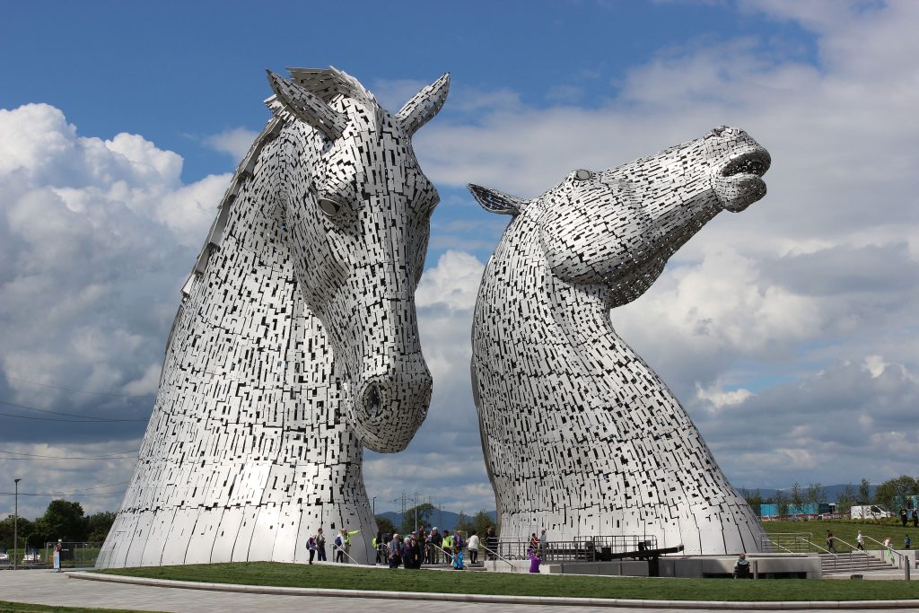
Attractions in and around Falkirk include the Falkirk Wheel, The Helix, The Kelpies, Callendar House and Park and remnants of the Antonine Wall. In a 2011 poll conducted by STV, it was voted as Scotland’s most beautiful town, ahead of Perth and Stirling in second and third place respectively.
Forts and Fortlets associated with the Antonine Wall from west to east: Bishopton, Old Kilpatrick, Duntocher, Cleddans, Castlehill, Bearsden, Summerston, Balmuildy, Wilderness Plantation, Cadder, Glasgow Bridge, Kirkintilloch, Auchendavy, Bar Hill, Croy Hill, Westerwood, Castlecary, Seabegs, Rough Castle, Camelon, Watling Lodge, Falkirk, Mumrills, Inveravon, Kinneil, Carriden
Romans (Antonine Guard Living History Society) saluting at Callendar House
An Eaglais Bhreac is a derivative formed from the Scottish Gaelic cognate of the first recorded name Ecclesbrith from the Brittonic for “speckled church”, presumably referring to a church building built of many-coloured stones. The Scottish Gaelic name was calqued into Scots as Fawkirk (literally “variegated church”), then later amended to the modern English name of Falkirk. The Latin name Varia Capella also has the same meaning. Falkirk Old Parish Church stands on the site of the medieval church, which may have been founded as early as the 7th century.
The Antonine Wall, which stretches across the centre of Scotland, passed through the town and remnants of it can be seen at Callendar Park. Similar to Hadrian’s Wall but built of turf rather than stone so less of it has survived, it marked the northern frontier of the Roman Empire between the Firth of Forth and Firth of Clyde during the AD 140s. Much of the best evidence of Roman occupation in Scotland has been found in Falkirk, including a large hoard of Roman coins and a cloth of tartan, thought to be the oldest ever recorded. A Roman fort was confirmed to be found by Geoff Bailey in the Pleasance area of Falkirk in 1991. A Roman themed park at Callendar House was awarded lottery funding to help raise awareness of the wall.
In the 18th century the area was the cradle of Scotland’s Industrial Revolution, becoming the earliest major centre of the iron-casting industry. James Watt cast some of the beams for his early steam engine designs at the Carron Iron Works in 1765. The area was at the forefront of canal construction when the Forth and Clyde Canal opened in 1790. The Union Canal (1822) provided a link to Edinburgh and early railway development followed in the 1830s and 1840s. The canals brought economic wealth to Falkirk and led to the town’s growth. Through time, trunk roads and motorways followed the same canal corridors through the Falkirk area, linking the town with the rest of Scotland. Many companies set up work in Falkirk due to its expansion. A large brickworks was set up at this time, owned by the Howie family. During the 19th century, Falkirk became the first town in Great Britain to have a fully automated system of street lighting, designed and implemented by a local firm, Thomas Laurie & Co Ltd.
Battles of Falkirk.
Two important battles have taken place at Falkirk:
- The Battle of Falkirk fought on 22 July 1298, saw the defeat of William Wallace by King Edward I of England.
- The Battle of Falkirk Muir took place on 17 January 1746, the Jacobites under Charles Edward Stuart defeated a government army commanded by Lieutenant General Henry Hawley.
Government and politics.
A map showing the boundaries of the Falkirk Council area, one of the 32 unitary authorities of Scotland. The town of Falkirk sits at the heart of the council area.

In terms of local government the town sits at the heart of Falkirk Council area, one of the 32 unitary authorities of Scotland formed by the Local Government etc (Scotland) Act 1994. The headquarters of the council are located in the Municipal Buildings, adjacent to FTH Theatre, on West Bridge Street in the centre of town. The Council has been led by an SNP minority since 2017. The current Leader of the Council is Cllr Cecil Meiklejohn. The FTH Theatre (the “Falkirk Town Hall Theatre”) in West Bridge Street was commissioned to replace the old town hall in Newmarket Street which was demolished in 1968.
Falkirk is located within the Scottish parliamentary constituency of Falkirk West which elects one Member of the Scottish Parliament (MSP) under the first past the post system. The current MSP is Michael Matheson, who won the seat at the 2007 Scottish Parliament General Election. The previous MSP, Dennis Canavan, who sat as an Independent, was elected with the largest majority in the Scottish parliament representing Falkirk’s electorate’s displeasure with New Labour, but stepped down in 2007 for family reasons. Canavan, who announced in an open letter to his constituents in January 2007, that he was stepping down from representative politics at the Scottish Parliament election, 2007 had been an MSP or MP for the area for over 30 years. The constituency of Falkirk West also sits in the Central Scotland Scottish Parliament electoral region which returns seven MSPs under the additional member system used to elect Members of the Scottish Parliament.

In the Parliament of the United Kingdom, the town is entirely contained within the UK parliamentary constituency of Falkirk which elects one member to the House of Commons under the plurality system. The constituency also takes in surrounding villages and is currently represented by John McNally of the Scottish National Party. Traditionally, Falkirk had been seen as a stronghold for the Labour Party.
Prior to Brexit in 2020 it was part of the pan-Scotland European Parliament constituency which elected six Members of the European Parliament (MEP)s using the d’Hondt method of party-list proportional representation.
Geography.
Falkirk and Stenhousemuir

Falkirk is located in an area of undulating topography between the Slamannan Plateau and the upper reaches of the Firth of Forth. The area to the north of Falkirk is part of the floodplain of the River Carron. Two tributaries of the River Carron – the East Burn and the West Burn flow through the town and form part of its natural drainage system. Falkirk sits at between 50 metres (164 ft) and 125 metres (410 ft) above sea level.
The underlying geology of the town of Falkirk is characterised by glacial deposits. Elevations above 100 metres (328 ft) are covered by a mixture of glacial till and boulder clay with low-lying areas covered by sandy soils and loams. As Falkirk is not far from the coast, post-glacial features akin to raised beaches are particularly predominant to the north of the town centre, and this gives rise to differing elevations within the town.
Unsorted glacial till gives rise to such features of glacial deposition as eskers, and drumlins which are predominant over much of the area. Such elements provide natural transport routes and it is this complex underlying geology that the town is built upon.